|
|
|
|
| ||
CHOLISTAN
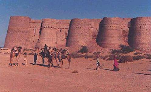 Cholistan is locally
known as Rohi. This famous desert is 30 Km from Bahawalpur and comprises of an area of 16,000 sq.km. which extends upto the Thar desert extending over to Sindh. The word Cholistan is
derived from 'Cholna' which means moving. The people of Cholistan lead a semi-nomadic life, moving from one place to another in search of water and fodder for their animals.
Glimpse of historic and Folk colours of bahawalpur
|
whats a missing? Something about governament missing will be comingsoon |
|||||||||||||||||||||||||||||||||||||||||||||
|
|
|
|
|
|
|
|
| |||||||||||||||||||||||||||||||||||||||
|
The way of life is also about to change. The women folk in drab landscape of desert wearing nath (nosegay), katmala (necklace), kangan (big bangles), pazeb (worn on toes), bright color, and vivid pattern lehngas of 20 yards and high cholis may one day become part of history. Maybe not so in near future! Sofi poet Khawaja Ghulam Farid, who spent 18 years of his life wandering about in Cholistan, admiring its beauty and people wrote, "But what tongue shall tell the glory of it, the perpetual strength of it, and sublimity of its lonely desolation! And who shall paint the splendor of its light." The poet was passionately found of desert milieus that are hard, dry and at first repulsive. His fascination for Cholistan was so rich that his poetry has woven melodious aura all around Rohi -- as the desert is called in a local dialect. He has set the standards for desert wanderers. I can tell you something of what I have seen during my intermittent stay - from 1977 till 2000 - in the desert, but I cannot tell you the grander of the desert, nor the glory of colors that wrap the burning sand. The awesome vistas and richness of the desert are beyond description. Cholistan is a land of legends, myths, velour, romance, folk melodies and regal elegance. At the tail of monsoon region, Cholistan stands as if petitioning the sky for rain. It very seldom falls. And whenever the prayers are answered, the water is stored for human being as well as animals in reservoirs known as `kunds'. Average rainfall in the area is 3 to 5 inches a year. Nomadic Holystones are constantly moving in search of water that is scarce, lies very deep, and is brackish. The lack of fresh water for drinking and irrigation controls the lives of the people of the region. A Saraiki poet once wrote, "Men tassel, merry dart tarsi, tee tarsi Rohi jai, melon ankh an pan dryad." It seems as if Cholistan is still mourning for the demise of the River Hacra. Cholistan is one of the fantasy regions for local as well foreign tourists, geologists, historians, archaeologists and naturalists.
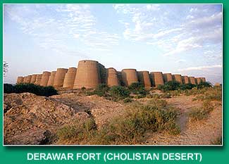
Botanically divers Cholistan comprises of dry, wet, and green lands. Southern portion is called greater Cholistan with sand dunes rising high unto 100 feet. Even in dry tract there are hundreds of species of plants as Kandi, Ak, Wild Carper, Qatran, Ber and Khar with well-established root system in the environment. The loamy soil with lot of vegetation in northwestern portion is known as lesser Cholistan. Green areas are intensively cultivated with thriving plantation. Wildlife in Cholistan (95 per cent of that has already been destroyed, though officially protected) has to blend rather than hide. On several occasions I nearly bumped into a flock of deer that was hiding into bushes as I approached. At night I once saw startled fawn gazing right into the headlights of my jeep. Many a times I came across feathers of Tiloor (Houbara Bustard) killed by poachers, though could not see one flying. Houbara Foundation International is trying hard to save the guest bird that is at the verge of extinction due to reckless hunting by 'royal dignitaries' who come in Cholistan every year. A renowned naturalist Jamal Hamid writes, "This desert is a particularly promising venue for the study of animals." Cholistan attracts not only the highest number but also the highest variety of wildlife that is not found anywhere else in Pakistan. Most of the 'honored guests' come from north. Most famous variety of local wildlife (Parha (hog deer), Neel Gaee (blue bull), and Black Buck) are still available in the areas near border. Majority of these creatures is nocturnal and shy, so watching of these requires endurance and good pair of binocular. Wild cat, jackal, wolf, mangoes, squirrel, field rat, over 200 types of insects and as much as sixty varieties of snakes are found in 10400 square miles of this rain less tract. Those who take their first chance on by train to Feroza, a small Railways Station on main track, find multiple tracks that originate from Feroza (more of a military railway station) and interlace the expanses of Cholistan. One has to muscle his way along these tracks lined with army camps: army personnel come to Cholistan for practice firing of heavy caliber weapons. Cholistan has some fifty sites and forts of Harappan demeanor. Derawer (also known as Dera Rawal, Deogarh, Dilawer, and Derawat) is situated in a dry bed of lost river Hacra. Sir Aural Stein during survey of Cholistan described it as "a place where occupation continued beyond pre historic times." It was once the centre of Aryan culture. In 1759, it was taken over by Abbasi Amirs and remained capital of Bahawalpur State. The city of bazaars, schools, madrassas, mosques and a headquarters of Bahawalpur Transport Camel Corps, in its hay days, lost its importance when it ceased to be the state capital. Now this place of antiquity is famous for the relics of the largest and most imposing of the Cholistani forts. Derawer Fort was built by Deoraj, a prince of Jaisalmir. The lofty and rolling battlements of the fort are visible from a long distance. The fort has 40 battlements made of thin red bricks. There are two old vintage guns mounted on pedestals in the dusty courtyard of the fort. The Abbasi Amirs and Nawabs are buried in a hall with engraved doors. On the western side are old dungeons and under ground rooms now infested with bats and rats. As per the myth the secret to change metal into gold was told to Prince Deoraj by his mentor jogi and there still is a treasure hidden somewhere in the fort. In 1825, Nawab Bahawal Khan constructed a mosque with cupolas and domes of exquisite marble. The mosque is a living glory of the place.
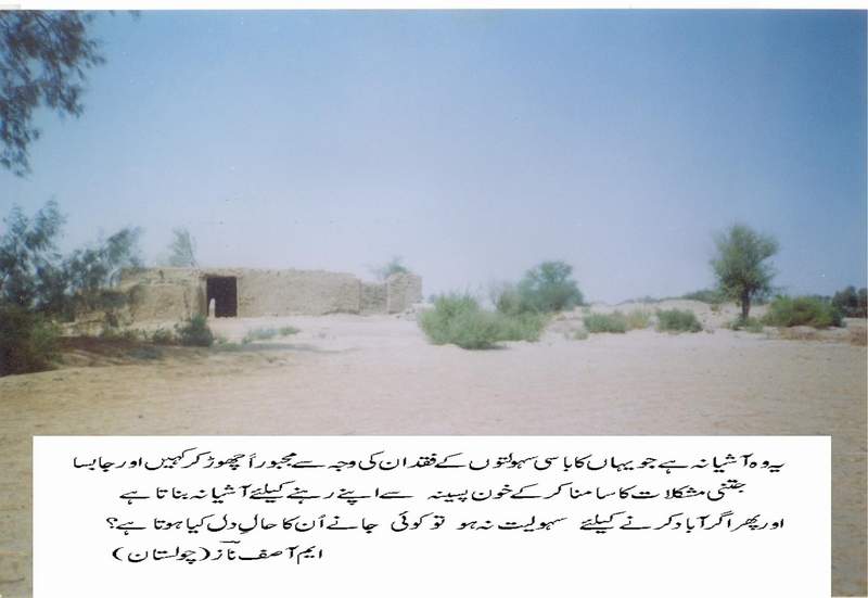
There is a large difference between rhetoric and realities in Cholistan. It is a tranquil, pollution free and quite destination. Visiting such a place is very simple and plenty of fun. The enjoyment increases exponentially with the level of interest. But, what of those who are living there. It seems pretty hard! |

|
Channan Pir Festival in Cholistan 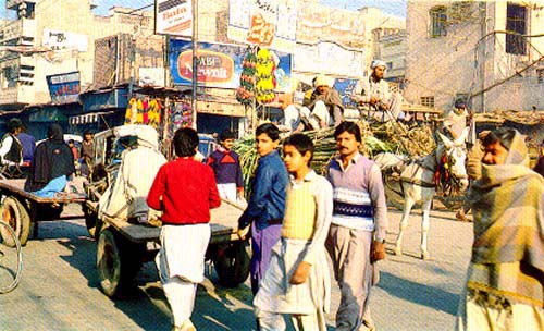
Channan Pir Festival in Cholistan
By Tahir Imran Khan
Channan Pir was the saint of desert. His place of burial has been marked in a small village named after him as Channan Pir. There is an annual festival at Channan Pir when people from different distant places comes to the place. The place becomes bustling and colourful in these days, especially now after being connect by metalled road. The festival starts from the last Thursday of February (Hindu month of Chaitra) and lasts for seven consecutive Thursdays.
Cholistan, one a fertile and cultivated land fed by Hakra River (also known as Ghaghra) supported a civilization. After the drying up of this river this area turned into a vast arid zone with two main portions i.e. Lesser & Greater Cholistan.
The are has experienced a succession of climatic changes over the last 500,000 years with a deep layer of red soil below the present sand surface suggesting a moist and green environment during upper and middle Paleolithic periods.
Over 400 archaeological sites have been uncovered along the dried up bed of the Hakra River. In addition to evidence of numerous stone age settlements at the lower levels, a series of desert forts have been built to guard the trade route across Cholistan, the best preserved of which is Derawar Fort.
The name Cholistan is derived from Urdu workd, Chalna, means to walk, although it is not clear whether this refers to the shifting of sand dunes or the semi nomadic people who roam in search of water and pastures/oasis.
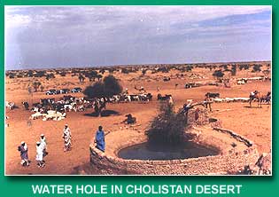
The annual rainfall is average 5 inches a year so there is a very little cultivation. The underground water is brackish. People of the desert dig wells in the troughs between sand hill and use camels to draw the water up in thick leather buckets. In the rainy season, they dig artificial ponds called Toba (s) and when these dry up they move on to find other watering holes.
Villagers of the desert live in mud huts, square in shape, and well ventilated with geometrically lined holes cut through the walls. The nomads live in high round huts, which are built on the highest sand hills out of straw and grass. These Aryan origin people are tall and handsome with sharp features. They live by raising cattle, sheep and breeding camels. Their women wear long gathered skirts, brightly coloured, and move gracefully as they perform their daily chores. The nomad's move form village to village where they get water from underground khus (wells), herding their livestock. The principal desert tribes are Chachar, the Mehr, the Larr, the Paryar, the Channar, the Chandni and the Bohar. The people are extremely friendly and hospitalbe.
Derawar Fort
Derawar Fort is one of the most impressive monuments of our heritage. The present building is built by Abbassi family in 1733 but it was there from centuries. Its walls are 30m high and there are 40 bastions, 10 on each side. A huge defensive tower at the main entrance to the East was added in 1965.
How old is Derawar actually, no one precisely knows. The huge fort stands on top of a ruined city of the mature Harrappan civilization that spans a period between 2500 to 1500 BC. The Hakra River, which once flowed close by dried up some 3500 years back draining life out of a mighty civilization. In the 9th Century AD to be exact, the site attracted the Bhatti Rajputs of Jaisalmir and Bikanir who built here a huge mud fort. Raja Rawal Deoraj gave the place his name, as Dera Rawal. With the passage of time, the name changed to Dera Rawar and finally to Derawar as to today. According to some, Derawar is actually another form of the word Derawar i.e. Dravidians - the original inhabitants of the Indus Valley Civilization.
It is constructed from gypsum blocks and is two walls thick. The fort was taken over by a family of rulers from Bahawalpur who restored the fort extensively using bricks transported from Uch some 65kms away. The bricks were carried to Derawar in a peculiar way a human chain of men was set up all the way from Uch to Derawar and the bricks passed from hand to hand so as to form a human conveyor belt.
The buildings inside the fort are, Harem, subedar's quarters, arsenal and a mosque. An interesting building is the multi-roomed subterranean summer rest house of Nawabs called Sard Khana. The iron rail to take Nawab's carriage is still intact. There are also remains of a watchtower, a prison, the granary, a guard house and some 100 new inaccessible tunnels - the rumoured subterranean chambers with buried treasures of the former rulers. The once gaily painted rest house or baradari on top of the north-eastern bastion still flies high the flag of the once ruling family of the former Bahawalpur State as a symbol of their authority over the area.
Close to the fort is the royal cemetery with marble and glazed tile work on graves. The graves of the rulers themselves, save the first, are however under one roof. It is beautifully decorated hall embellished with fresco paintings on the walls, mirror work on the ceiling and carved marble cenotaphs. Over some of the graves hang costly chandeliers. Outside the main hall, pure white marble tomb of a Christian European wife of a former rulers of special interest. As a family place, it is also closed for visitors.
The most impressive building surviving outside the fort is Jama Masjid of pure white marble brought over a distance of undreds of miles away. This was built by Nawab Sadiq in 1848, after starting construction in 1842. Later Khawaja Ghulam Farid, the famous Sufi saint, occupied this mosque. There is a legend that his name has been imprinted by a miracle on the main doorstep (though it may be written by dropping an acid on the stone slab, as it is not painted nor chiselled). His tomb is in Mithankot.
Khawaja Fareed (1845-1901) was much attached to Thar Desert where he spent years and married a girl from nomad tribe. He also nentions frequently about the beauty of this area and of the local people. He also refers the romantic story of Sassi & Punnon in his poems.
500m NW of the fort are graves of four companions of Hazrat Muhammad (peace be upon him). Detail are not known.
Dera Nawab Sahib is at a distance of 45 kms from here. There is a fine building Sadiq Garh Palace in Dera Nawab Sahib.
Trekking the Cholistan Desert
|
Things to See and Do There are a number of forts along the old river bed dating
back to 4000 BC. The Forts were built to guard the ancient
trading routes. Shrines of Channan Pir - 30 miles from Derawar Fort. A festival is held annually at the start of March where devotees gather on the night of the full moon to honour the tomb of saint Channan Pir. Shopping - You can buy locally produced Cholistan crafts at the Craft Development Centre outside Farid Gate. Best buys including a Flassi (camel hair wall hanging or decorative carpet), a Gindi (cloth needlework covering used as spread or tablecloth), Khalti (multi-coloured embroidered purse)or a Changary (geometric plague made of palm leaves). Trekkers Essentials: - Bring plenty of food and water. Oasis's are rare in this desert. - For the more adventurous is it possible to pay for a permit
at the Bahawalpur office of the PTDC (Pakistan Tourism Development
Corporation) and stay independently in the desert, but the
logistics involved in bringing in your water and food supply
and arranging for a pickup back out, make this option not
particularly viable. - Best time to visit is winter - October to March when the temperature ranges from 8C - 23C. - Four wheel drive and camel tours can be arranged to take you into the Cholistan and to the fort, but for a quick day visit it's best to hire a car and driver for the 'relaxed' experience. Prices are extremely cheap, but make sure you choose your car and driver wisely.
| |||||||||||||||||||||||||||||||||||||||||||||